Roadwurx Launches Municipal Referral Program to Reward Highway Departments for Sharing Success
Published on July 8, 2025
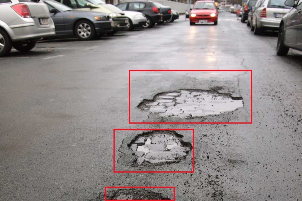
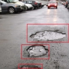
Potholes are more than a nuisance. AAA estimates they cost U.S. drivers roughly $3 billion in vehicle repairs every year, much of it paid out of pocket. Municipal public-works teams spend millions more filling the same holes year after year because they learn about them only after residents complain or crews spot them by chance. Computer-vision pothole detection promises a quieter, data-driven alternative. (info.oregon.aaa.com)
Smartphone- or dash-mounted cameras capture images every few metres while normal fleet vehicles go about their routes. The images are time-stamped and GPS-tagged, then uploaded to a cloud platform where convolutional neural networks classify defects, everything from hairline cracks to full-depth potholes. Systems such as Vialytics take a shot about every 10 feet and automatically blur license plates to stay privacy-compliant before analysis. (vialytics.com) The model returns a condition score and map layer that public-works managers can feed straight into work-order software.
Vialytics. The German-American platform recognises 15 damage classes and already supports more than 600 municipalities. Case studies from North Tonawanda and Metuchen show crews shifting from reactive patching to planned maintenance after a single survey drive. (vialytics.com, vialytics.com)
RoadBotics (now a Michelin company). A windshield-mounted smartphone records video; the AI masks pedestrians and vehicles and outputs a colour-coded pavement map. Detroit was the first major U.S. city to adopt the system, and more than 160 governments have used it for network-wide assessments. (blogs.nvidia.com, traffictechnologytoday.com)
Memphis pilot. Cameras on four Public Works trucks feed video to a Google-hosted model that detects potholes, clogged drains and illegal dumping with about 90 percent accuracy, automatically generating work tickets. A city-wide launch is scheduled for early 2025. (statescoop.com)
CityRover and other newcomers extend the concept with real-time dashboards and API hooks so defect data can flow into existing asset-management or 311 systems. (cityrover.com)
Faster, network-wide surveys without closing roads or renting LiDAR vans
Objective condition scores that tie directly to capital-planning logic
Early warning of small defects, reducing cost per repair and liability risk
Clear visuals for councillors and residents, strengthening budget requests
Research shows model accuracy can drop in poor lighting, rain or snow, because shadows and puddles mimic pavement defects. A 2022 study using YOLO v3 describes this sensitivity and calls for continuous retraining on local images. (mdpi.com) Other hurdles include data-storage costs, integration with existing work-order systems and the need to fine-tune alert thresholds so crews are not flooded with low-priority tickets.
Pilot on a representative route. Pick varied pavement types and lighting conditions to gauge false-positive rates.
Validate against your current rating method. Run a manual survey on the same corridor and compare scores.
Plan for data flow. Budget both the subscription fee and any GIS or CMMS integration costs.
Update procurement specs. Require automatic face and plate blurring, open APIs and raw-image retention for audit trails.
Edge devices that run models onboard the vehicle will cut upload times, while UAV-based inspections and multi-sensor rigs (thermal, ground-penetrating radar) are already in prototype. Some vendors are exploring predictive models that estimate when a crack will become a pothole, letting engineers schedule a preventive seal rather than an emergency patch. (mdpi.com)
Computer vision flips pothole management from reactive to predictive by turning ordinary fleet vehicles into rolling inspectors. Early adopters report faster surveys, clearer maintenance priorities and better use of limited road funds. Results vary, so start with a small-scale pilot, insist on open data pipes and keep calibrating the model to your climate. Do that, and the technology can help your crews fix the next pothole before it wrecks the next suspension.

Roadwurx Launches Municipal Referral Program to Reward Highway Departments for Sharing Success
Why Every Road Department Should Use Asset Management Software

Breaking Silos: Using Shared Dashboards for Cross-Departmental Visibility
5G + Edge Computing for Adaptive Traffic Signals
Computer Vision Pothole Detection

Open-Source Alternatives: When They Make Sense